
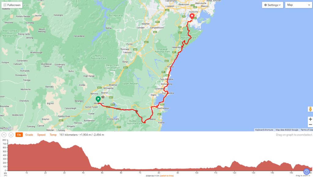
Saturday 14th May, 2022
161km +1904m
Moving 7:56 Elapsed 12:23
Max 60.1 kph Avg 20.3 kph
I guess the big day ahead was making me a bit anxious. While I had well and truly given up trying to eat before sunrise, I had been managing to at least drink a cup of coffee (and by then I was well and truly used to hotel/motel instant coffee). Not this morning though. Brought it all up again.
After extricating the bike and gear down the hotel stairs – trying to be quiet, but at the same time feeling like bashing and crashing around to exact at least some revenge on the other guests who weren’t exactly quiet when they headed for bed well after midnight!
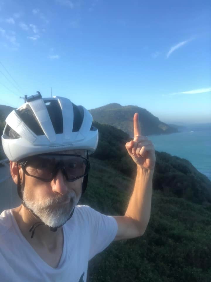
At 6.15 – half an hour before sunrise – we set off through the streets of Moss Vale and turned onto the Illawarra Highway. This was a familiar stretch of road to us, as we had lived around here for several years (well, at least ten years for Marc, and eight years for me.) We weren’t doing much in the way of cycling back then, so we had never ridden it, but, knowing what it was like, I was a bit concerned, to be honest. It would be a pretty bad section to do during peak times during the day. I was glad we were doing it this early. Maybe fully dark would have been better, because, in this pre-dawn gloom, it was incredibly difficult to spot the dark-coloured vehicles with no headlights in our mirrors. Makes you go GRRRR.
At 13k we passed the turnoff to Burrawang – the village where we owner-built our first house. (We started it in 1990, moved in in 1994, and moved away in ’97. We sold it a few years later. A part of me would like to ride through there for old times’ sake, but a bigger part of me wouldn’t cope with seeing the house again.
We pulled up at the bakery in Robbo – Robertson – at 7.30. (22k down.) It was light now, so breakfast.
3km beyond Robbo we took the turn off onto the detour – Jamberoo Mountain Rd. We’d be doing an extra 10km compared to the Macquarie Pass route. So, the first 10k was pretty nice, but then we had 5km of really steep downhill – at an average grade of about -10.4%, which was really hard on the tandem. Also not great with the traffic gradually building up. Of course there was more traffic on it than there would normally be – much of it was having to do the same detour as us!
We stopped on the outside of a hairpin bend about halfway down, to let the brakes cool. It was a relief when it flattened out.
We came to a T-intersection just out of Jamberoo. Left turn. Now for the 9km over a hill to Albion Park to rejoin the route. That wasn’t much fun – no shoulder, then some narrow, crappy shoulder, plus impatient traffic. My phone rang at one point. What the heck? It was my dad, who, with his dementia, was clearly oblivious to the fact that we would be riding. (I couldn’t answer it – another one for my sister to handle if he didn’t figure out why I wasn’t answering.)
In the middle of Albion Park we made a right turn – and we were back on route on the main drag (Illawarra Highway turned Tongarra Rd). Then another turn, onto the Princes Highway (yes, that Princes Highway!) at Albion Park Rail. The turn-off to Oak Flats – only 4k – couldn’t come soon enough. By then the highway was looking more like a freeway and we had to negotiate an off-ramp that just ran out of shoulder.
We found a cafe in Oak Flats. Time for a break, and a second breakfast… brunch…whatever it was. It was 10am. 63k down.
More backstreets, and then an esplanade (then parade) along the edge of Lake Illawarra. It was just along here (where the official route turned onto the main road Windang Rd, over the bridge) that we were going to take another detour, using a safer route recommended by local, and 2021 IPWR alumni, Eddie B. That proved to be more complicated than intended. We looped under the bridge, as per Eddie’s route, so as to cross over on the bike path on the eastern side of the bridge, only to find it was closed! We ended up scuttling across the 4 lanes of traffic to get back to the western side, used the footpath on that side, then doubled back around and under again. All time-consuming – but looking at the main road, I was glad we weren’t on it.
A few blocks on a quieter street, and then we joined a bike path that ran alongside Windang Rd/Primbee Bypass. Again, very glad not to be mingling with three lanes of traffic in an 80kph zone. The only time you would want to ride it (as per the ‘official’ route) would be in the middle of the night.
After about 4k we hung a left (on Shellharbour Rd) and wove our way through Port Kembla, and then through the industrial area.
It was along here that I realised I had messages coming in from my sister. ‘Hiya, you guys ok? Still in Moss Vale?’ Errr, no. only 5 and a half hours and 80km away! We stopped to try to figure it out, and I posted on the dotwatcher page.

We kept moving. Turned out it wasn’t a tracker issue in so much as it was a ‘nobody has ever taken this long to complete Indipac before’ issue. Once Damian contacted MAProgress they quickly extended the event date and we were on the air once more.
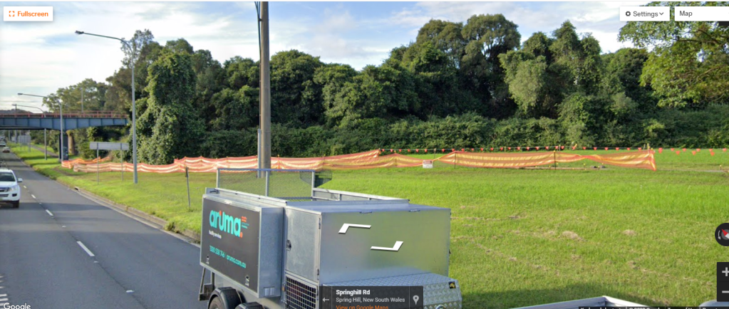
We were on another bike path at that point and stayed on it as our Port Kembla detour rejoined the route at Five Islands Rd – which was still an 80kph zone with three lanes of traffic. We hung a right into/alongside Springhill Rd (still 3 lanes of 80kph!) and were foiled by a section of the bike path being closed – so we had to walk it around.
I can’t help being intrigued as to why the original IPWR route-setters didn’t make use of these bike paths through ‘The Gong’ when they used them extensively through all the other major cities – Adelaide, Geelong, Melbourne, Canberra and Sydney. It’s like, by the time they got to Wollongong they had given up. I guess maybe in 2017 the paths weren’t there, but that just highlights that it’s a bit nuts to just enshrine the original route as kind of holy or something. Marc does make the observation that some of these paths on this Wollongong detour were a bit, well, footpath width. I’d still rather ride them than those busy main roads!
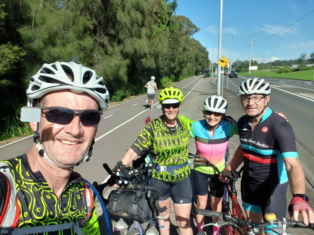
A few k’s along from there we spotted a bike coming towards us on the path. Not just a bike. A tandem! It was cycling friends, Liz and Dave. We’d been trying to tee up a rendezvous with them as we rode through the Gong, made more tricky by the fact that they were packing to go away the next day, we didn’t really know what time we’d be riding through, we had a huge day and wouldn’t want to stop for long, and whether (and what) we’d be wanting to eat at that point or not. Then of course the tracking issues made it even more difficult. They had decided, however, to ride out on their tandem to find us. We had met them years ago when they were riding a Bike Friday tandem, we had since actually sold them one of our old tandems – a Cannondale Los Dos that I had ridden with one of our daughters. It brought back a few memories seeing it again!
Liz must have brushed up on Eddie B’s route, as they led us on that, past Wollongong Beach and Flagstaff Point, and North Wollongong. They realised at that point that they had a flat tyre, and they had just jumped on the bike without bringing any spare tubes. They weren’t too far from home at that point , so we said our thank yous and byes, and left them to limp home. Their recommendation was to get back on road and on the route (Pioneer Rd) at the next cross street (where the bike path finished) instead of continuing with Eddie B’s slower shared path through Towradgi, Corrimal and Bellambi. Having ridden that path on the Sydney to Gong, and having just dealt with all the weekenders meandering all over the path, we decided that was the go. It would be faster, and we still had a way to go yet.
We followed the route through to Bulli Beach. It was 1.00 and we were more than ready for some lunch. We pulled up at Bulli Beach Cafe and went in to try and find a seat. A beachside cafe during the Saturday lunch rush? Bad idea. It was way too crowded. Google maps time. There was a cafe a block off route at Sandon Point, only 1k up the road. Back on the bike, ride one kilometre, and then, finally: Lunch. Fuel. 100km down.
It was 2pm as we got back on the bike, and dutifully went back down the hill to rejoin the route where we had left it – just as it was actually joining a shared path. Oh for heaven’s sake, it was ANOTHER bike path closure! Halfway back up the hill, down a street, and onto the path beyond the closure. (Good use of shared paths with route choice here; only a kilometre, but it got you through the back of McCauley’s beach (and over a creek) to Thirroul without having to use the Princes Hwy.
After another kilometre of quiet back streets, we then had to turn onto Lawrence Hargrave Drive – the main road through the northern beachside villages of Wollongong – Austinmer, Coledale, Scarborough, Clifton, Colecliff and Stanwell Park. It’s the main route for day trippers taking the scenic route back up to Sydney- via the Sea Cliff Bridge, and up the escarpment to Stanwell Tops. It wasn’t fun, dealing with cranky impatient drivers.
When everyone jokes that once you get over Cabramurra to Canberra ‘it’s all downhill to Sydney’, they forget that the route preemptively takes you down the escarpment to the coast to Greater Wollongong, only to have to go back up it again to get to Sydney! (And then down and up through the Royal National Park!)

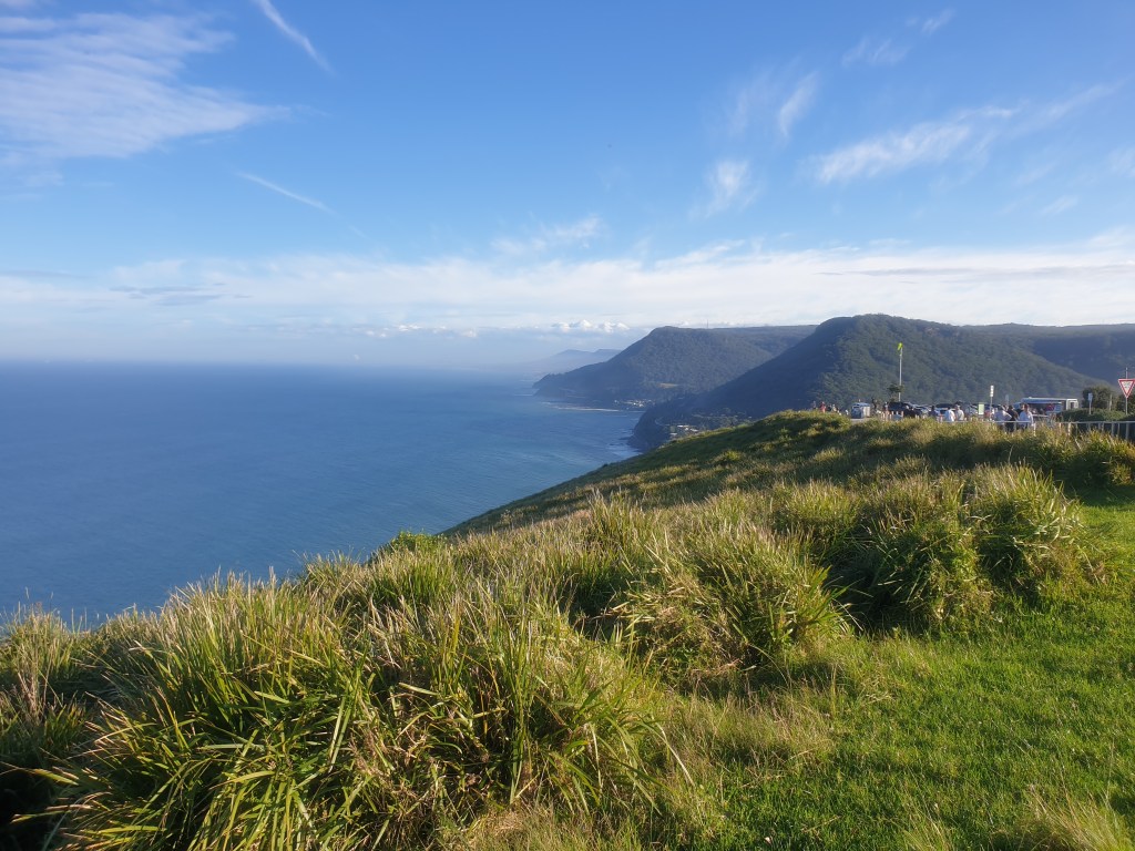
We got a bit lucky. There were roadworks at the bottom of the climb up to Stanwell Tops, with a stop/go sending traffic up, and we snuck through as the last ‘vehicle’ in one batch. Up the climb we had about 3 or 4 pulses come through. There was nowhere to pull off, so we gritted our teeth through it, and then got a bit of a reprieve in between.
For all my complaining (with terrain map above), it was really only a couple of tough k’s of climbing. (Max 13%, avg 9%!). Thank goodness only a couple of k’s. There was a cafe/kiosk at the top, so we stopped for a break.

119km down and 3.30pm. STILL a fair way to go, through the National Park, and then several more kilometres through suburban streets to the motel.
We found out later that Eddie B (of the safer route detour and 2021 IPWR) had set out to meet us, but missed us. That was a shame, it would have been great to meet him.
At the intersection near the kiosk, the ‘SYDNEY via FREEWAY’ sign pointed in the opposite direction to our route, so pretty much all the traffic headed that way. Thank goodness! We set off again, heading for the Royal National Park along Lady Wakehurst Drive. We had ridden this road in the other direction a few times – on the Sydney to Gong Ride – many years ago.
We had 12km of easy riding – mostly downhill – to an intersection with McKell Ave, which is the quickest way out of the park from here – heading west, up to Waterfall. (This was the road you come down on the Gong ride.) The Indipac route, however, continues winding northwards (after doubling back southwards!) through the park along what is now Sir Bertram Stevens Drive. Another 22km up to the Princes Hwy at Loftus. That road crosses Audley Weir, and we had been warned that the weir had been closed due to flooding. At this McKell Ave intersection, there was a big VMS (Variable Message Sign) about the weir. We can’t remember the details now, but it was really unclear as to whether it was activated or not, current or not. If the weir was actually closed we would just hang a left now and take the detour (only 5k) up to Waterfall (then ride the Princes Hwy to Loftus.) There were cars coming from that direction, so we flagged one down and asked if he’d come through Audley Weir. He had, so, onwards. In hindsight, I kinda wish it had been closed!
Straight into a 6km climb. We emerged out of the gloom of the forest onto a bit of a plateau, just about on sunset. 5pm. So far it hadn’t been too bad with cars, but that all changed once we passed a few turnoffs to the popular day-trip beach spots of Bundeena and Maianbar, and, of course, there was a mass end-of-the-day exodus from these spots. The only slight positive was that the cars came in bursts of about 10 vehicles because there must have been a roadworks traffic control on one of those side roads. We managed those passes… just, and then we’d get a few minutes of respite (that I needed to rein in the panic attacks.) The impatience of all these drivers was palpable, and the close passes were real. Really REALLY bad time to ride through here!
We crossed Audley weir just after 5.30 and pulled off. We decided to wait for a bit. Surely, now that it was dark, the exodus would have to be easing off. It seemed that was the case, with fewer vehicles in each batch now coming through. We sat there for nearly half an hour. We had some mobile coverage at that time, so fielded a few messages from people concerned about the tracker not moving and it being dark! (Riding after dark was not our usual MO I must admit!) But guys! It’s pretty hard to get satellite pings when you’re riding under a dense canopy of trees!!
We took a deep breath and set off from the weir just before 6pm. It was only a few kilometres of climbing – but still with an average gradient of 8.2% and a max of 13%. At least there were fewer cars now, and we were up and out of there in about 15 minutes.
Relief at getting out of there was then replaced with some anxiety about riding on the Princes Highway – in the dark! At least it was only 1k (with a good shoulder) till the turn-off onto the Old Princes Highway. We rode through Sutherland, and then the back streets of Kirrawee. It wasn’t too bad then – we felt pretty visible with our lights – and anyone driving past didn’t seem to be in quite so much of a hurry.
We had booked a motel just near the route at Sylvania – Abcot Inn – and we rolled into there at 6.30. Sweet relief. We’d made it through today and we were going to make the Opera House by Sunday, having ridden the ups and downs of an emotional rollercoaster as well as the actual road. Tomorrow we still had 60km to ride, despite having technically made it into Sydney. For a grand finale the route heads along the edge of Botany Bay towards the city, but then loops out to the west, north over the Parramatta River, and then around so as to ride in over the Harbour Bridge.
The motel guy was really helpful (even more so when we told him about our ride!). We got the bike up the stairs and into the room. I got some washing on so we could ride our last day in non-smelly kit!
We got Uber Eats for dinner – a pizza I think – and messaged back and forth with more friends and family about tomorrow’s plans, as well as letting the dotwatcher FB group know. Many had been concerned that the Sydney Half Marathon was on in the morning. That was absolutely not going to bother us.
“Likely mid-afternoon finish tomorrow. Will be taking it nice and easy, and it won’t be an early start. Also means all the half marathon business should be well and truly over.”
My sister and her husband were bringing our van to the Opera House – as well as our daughters who had flown into Sydney today. Lisa was also having to organise Mum and Dad, who insisted that they’d be fine catching the train in.
Friends Malcolm (of the care package and fast downhills) and Roger were going to ride the route out to meet us and then ride with us to the Opera House. We revised back their estimations of where we’d be by 9.00 (Dolls Point!)
“We’re knackered from today! We’re going to have a sleep-in, leave the motel at about 8.30 and then stop not far down the road for breakfast!”
“We’ll find ya there”
Our last night. Feeling all the feelings.

Such an amazing trip. Going through it the second time really brings it home. Hope you are going to make it into a book. Blog2print is who I have used for a book keepsake.
LikeLike
Such an amazing trip. Going through it the second time really brings it home. Hope you are going to make it into a book. Blog2print is who I have used for a book keepsake.
LikeLike
Thanks Cheryl. It’s been kind of epic reliving it as I’ve written it up, especially over the past month as we’ve dot watched this year’s Indipac-ers!
Thanks for tip, will look into Blog2print.
LikeLike